

Sometimes when teaching the history of your town it can be difficult to engage your students. Here in Massachusetts, the curriculum frame works recommend third graders should learn about their town. Eight-year-olds are just beginning to be aware of and understand things outside of themselves (social, political, and other people’s personal issues). They are becoming less egocentric. This is a good time to start to learn about their town, because it is a place they are familiar with. A local history program can be given at the historical society, the history room at the library, or it can travel to the school, but if the bulk of the program is lecture based, the children may recall very little of what is discussed. Coming up with a program to activity engage the students can be difficult, and if this program needs to travel it can be even trickier. But if students have a hands-on program that is fun, then they will remember the history of their town for many years. Making all your efforts worthwhile.
Activity One: Maps….Old and New
One of the best methods to help students learn about the changes and growth of their town is to use maps. The wonderful thing about maps is that they have been around for hundreds of years, long before photography, and illustrate the changes a town has experienced over time. Select approximately four maps, the earliest should be from about the time your town was established and the newest should be relatively recent. Choose maps that children will find easy to read. Be aware this may be the first time these children may have ever read a map. The maps should also show the same area (neighborhood) over time, in other words, be very similar. You may want to highlight the main road or a particular intersection for ease of locating streets/buildings to help compare the maps to each other. Also, when making copies of the maps, make sure they are all oriented the same, north top of the page and south on the bottom, and number each map. Make plenty of copies so students can work in small groups, and then laminate them for longevity! (plus dry erase markers can be used on lamination)


Other items you may want to have on hand when using map cards, are photographs of landmarks, dry erase markers, and paper towels. Using the map cards, have children compare and contrast the maps. Can see any changes between map 1 and map 3? Can they note changes from map to map over time? Have them locate something familiar, and circle it. Have them draw a line on an older map showing where a newer road is today. The possibilities are endless with these cards.
Activity Two: Links & Chains
Did you know an acre was once considered to be the area one could plow in a day? As time went on, a particular size was settled on (43,560 sq ft, which is a little bit smaller than a football field) and surveyors were hired to measure the land and to draw maps. In fact, George Washington was a surveyor and his surveying equipment is on display at Mount Vernon.
For this activity you will need: paper and a pencil, a measuring tape, a kit with chains and rods, six stakes (or orange cones) to mark out the space (length) that children will measure, and a couple of land deeds (one that lays out the area in links and chains and one that lays out the area in feet). Have a copy of the original deed, but also provide a transcription so the children can easily read the deed.
Preparation: The children will be measuring three similar lengths. Set the stakes (or cones) out, one is the starting point and the other the end. Before the children measure these lengths, have them read the deed cards and discuss the different ways measurement is recorded. Ask why they think it is important to have a standard form of measurement.
Break the children up into three groups for the measuring activity. The first length will be measured using the students’ feet in heel-toe style, the second using the measuring tape, and the third using links & chains. Have each group rotate through each measuring activity so they all have an opportunity to try each type of measurements. Gather the children together to discuss their findings and again ask if they think it is important to have a standard form of measurement.
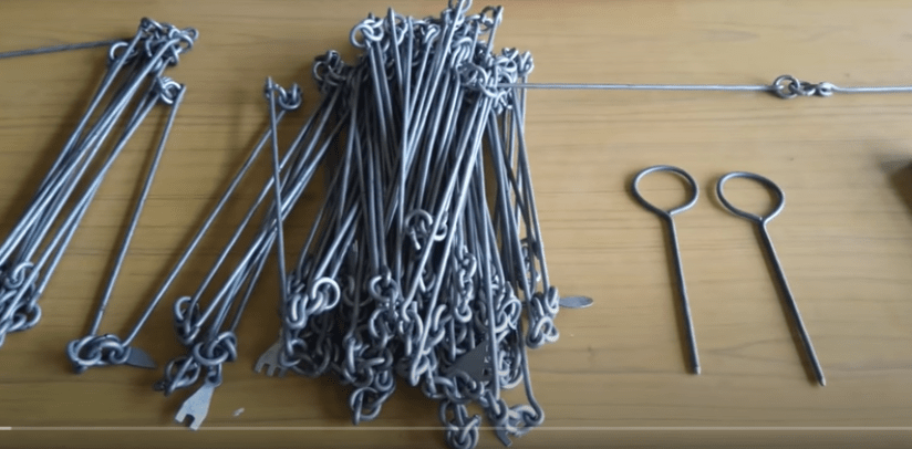
Historical Note: A Chain is 66 feet, there are 100 links in the chain, there are 4 rods in a chain. (A chain is a little less than a ¼ the length of a football field.)
An accurate chain is not necessary for this activity. It would be too heavy and difficult for children to handle. You will find a chain at your local hardware store. It is more important to have a chain with 100 links in it, even if it does not measure 66 feet.
Activity Three: Make a map of your neighborhood
The Norwood Historical Society (MA) has in its collection a map hand drawn by a resident (circa 1900) that shows how the town looked in 1840 how this resident remembered it. He notes homes, roads and businesses. It is a wonderful piece of memorabilia. Have the children draw a map of their neighborhood. Then take their maps to add to your historical society’s collections so some day a researcher will study them and perhaps use them as part of their project.
